The Geological Formation of Mount Everest: A Deep Dive into Its Origins
Mount Everest, the tallest mountain on Earth, stands as a magnificent testament to the dynamic forces of nature. Its geological formation is not only fascinating but also reveals a story that spans millions of years. Understanding how Mount Everest was created involves exploring the tectonic activities, geological processes, and the relentless forces of erosion that have shaped it into the iconic peak we see today.
The origins of Mount Everest can be traced back around 60 million years ago. During this time, the Indian Plate was on a collision course with the Eurasian Plate. This cataclysmic encounter is at the heart of Mount Everest’s formation. As the Indian Plate pushed northward, it began to subduct beneath the Eurasian Plate. This intense pressure caused the Earth’s crust to buckle and fold, leading to the uplift of the Himalayas, which includes Mount Everest.
One key aspect of this geological process is the concept of plate tectonics. Here’s a quick breakdown:
- Tectonic Plates: The Earth’s crust is divided into several large plates that float on the semi-fluid mantle below.
- Subduction: This occurs when one plate is thrust beneath another, forcing it to sink into the mantle.
- Uplift: The collision between the Indian and Eurasian plates resulted in the uplift of the Himalayan range, including Everest.
As the plates continued to push against each other, Mount Everest gradually rose higher. This process of uplift is ongoing, meaning that Everest is still growing today. Scientists estimate that the mountain rises approximately four millimeters every year due to this tectonic activity. The sheer scale of the forces involved is mind-boggling, with immense pressure exerted across a massive expanse of land.
In addition to tectonic forces, various geological processes have contributed to the mountain’s current form. Erosion plays a vital role in shaping Mount Everest’s landscape. Over thousands of years, glaciers have carved out valleys and are responsible for the rugged terrain surrounding the mountain.
The glaciers on Mount Everest also interact with the rock and soil, breaking down materials and transporting them downhill. This process not only alters the mountain’s structure but also contributes to new land formations in the area. It’s a continuous cycle of erosion, uplift, and sedimentation that collectively defines the Himalayan region.
The composition of Mount Everest is another fascinating aspect of its geology. The mountain is primarily composed of sedimentary rocks, including limestone, sandstone, and shale, which were originally formed in a shallow sea millions of years ago. As the plates crashed together and pushed the seabed upward, these once marine sediments became part of the towering mountain chain. Today, you can even find marine fossils embedded in these rocks at extreme altitudes, a testament to the mountain’s underwater origins.
Another significant geological feature is the presence of metamorphic rock that has been transformed by heat and pressure from tectonic activity. This contributes to the diverse geological landscape of the region. Mount Everest’s unique rock formations have made it a subject of study for geologists and researchers aiming to understand the processes of mountain-building and the Earth’s geological history better.
As climbers and adventurers trek up Mount Everest, they witness not only a physical challenge but also a journey through time. Each layer of rock and sediment tells a story about the mountain’s past and the forces that shaped it. Whether peering at ancient marine fossils or feeling the rugged texture of metamorphic stones, you experience the history engraved in the mountain’s very core.
Understanding how Mount Everest was created gives us a deeper appreciation for this natural wonder. It reminds us of the power of geological forces and the delicate balance of nature that continues to evolve. As you explore this breathtaking landscape, you don’t just see the highest point on Earth; you witness the enduring spirit of our planet’s dynamic geology.
Plate Tectonics and the Rise of the Himalayas
Mountains are impressive natural formations that tell the story of our planet’s dynamic past. The Himalayas, among the highest mountain ranges in the world, owe their existence to the fascinating science of plate tectonics. Understanding how these colossal peaks formed provides insight into the earth’s ever-changing landscape.
The Himalayas began to take shape around 50 million years ago, primarily as a result of a monumental collision between two tectonic plates: the Indian Plate and the Eurasian Plate. This process, known as orogeny, led to dramatic geological changes, pushing the earth’s crust upward and creating towering mountains.
The Indian Plate moved northward at a speed of approximately 5 centimeters per year, driven by the intense forces of mantle convection beneath the earth’s surface. When it collided with the much larger Eurasian Plate, it didn’t simply push against it; instead, it caused the two plates to crumple and fold. This folding produced the great heights of the Himalayas that we see today.
As the plates continue to push against each other, the Himalayas grow taller, albeit at a very slow rate. The average growth of the range is about 1 millimeter per year. This ongoing tectonic activity reminds us that our planet is still very much a work in progress, with mountains rising and valleys forming as geological forces shape the landscape.
There are several key factors that contribute to the rise of the Himalayas:
- Continental Drift: The movement of continents over millions of years has brought the Indian Plate into contact with the Eurasian Plate, initiating the mountain-building process.
- Subduction Zones: While the Indian Plate is primarily continental, it has some oceanic crust. When these plates collide, the denser oceanic crust tends to sink, allowing the continental crust to be pushed upward.
- Pressure and Temperature: The collision generates immense pressure and heat, resulting in metamorphic processes that further contribute to the mountain’s formation.
- Erosion: Though the mountains are rising, they are also subject to erosion from wind and water, which shapes their peaks and valleys over time.
The biodiversity and ecosystems found within the Himalayas also reflect the unique geological conditions. The range supports various climates, from humid subtropical forests at lower elevations to the icy tundras near its peaks. This diversity is due, in part, to the varying altitudes created by the tectonic uplift.
Interestingly, the tectonic activity that formed the Himalayas didn’t stop millions of years ago. Earthquakes remain a frequent occurrence in the region, reminding us of the geological forces still at play. The Indian Plate continues its slow march northward, and this movement fuels seismic events, shaping the landscape continually.
Researchers and scientists observe these events closely, studying the structure of the Himalayas and the surrounding areas. Advanced technologies like GPS allow geologists to monitor the shifting tectonic plates, providing a clearer understanding of how mountains form and evolve over time. This ongoing research highlights the importance of plate tectonics and its effects on the Earth’s surface.
The rise of the Himalayas is a captivating narrative of nature’s power over millions of years. Understanding how plate tectonics plays a significant role in mountain formation emphasizes the ever-changing nature of our planet. As the earth continues to shift and evolve, the majestic peaks of the Himalayas stand as a testament to the dynamic forces at work beneath our feet.
So, the next time you gaze at these towering giants, remember that they are not just beautiful landscapes; they are monumental reminders of our earth’s history and active geology.
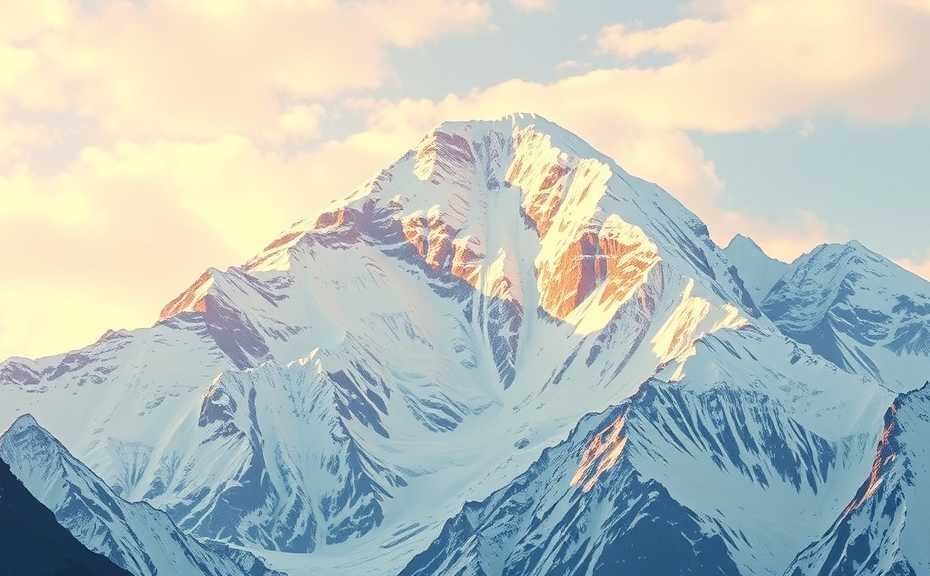
The Role of Erosion in Shaping Mount Everest
Mount Everest, known as the tallest mountain in the world, was not created overnight. Its formation is a product of millions of years of geological activity, where erosion plays a critical role. Understanding erosion’s influence helps us grasp how Mount Everest reached its current majestic height.
Erosion is the process through which natural forces shape the earth’s surface. It involves the wearing away of rocks, soil, and minerals, often fueled by elements like wind, water, and ice. This process is a vital part of the rock cycle, contributing to the ever-changing landscape of mountainous regions. On Mount Everest, various forms of erosion have interacted to create its unique features.
Types of Erosion Affecting Mount Everest
When considering how Mount Everest was shaped, it’s essential to examine the types of erosion at play. Each type contributes differently to the mountain’s structure:
- Glacial Erosion: Glaciers carve through rock as they move. In the case of Mount Everest, massive glaciers have been critical to its formation. The Khumbu Glacier, for instance, has further deepened valleys and created dramatic ridges over thousands of years.
- Water Erosion: Rivers and streams on the mountain carry away layers of rock and soil. Seasonal melting of snow and ice feeds into these rivers, causing substantial erosion. This process helps form valleys and alters the landscape surrounding Everest.
- Wind Erosion: High-altitude winds have the power to shape the mountain’s face. They can wear down softer rock layers and transport fine particles, slowly reshaping the topography.
Each of these erosional forces works hand in hand, gradually revolutionizing Mount Everest’s shape over countless geological periods. The combination of these forces not only sculpts the mountain but also impacts its surrounding environment, influencing local climate, vegetation, and wildlife.
The Role of Climate
Climate also plays an integral role in the erosion process. Mount Everest’s high elevation leads to harsh weather conditions. Extreme cold creates frost action, where water seeps into cracks, freezes, and expands, causing rocks to fracture. This cycle significantly contributes to rockfall, which further alters the landscape.
Additionally, the monsoon season brings heavy rain that accelerates water erosion. When coupled with the glacier melt during warmer months, the sheer volume of water rushing down the slopes increases the rate of erosion. As a result, the shape of the mountain is constantly changing, responding to the whims of the weather.
The Impact of Erosion on Mount Everest’s Features
The ongoing erosion processes have led to the formation of distinct features on Mount Everest:
- V-Shaped Valleys: Formed primarily by glacial activity, these valleys are among the most prominent features on Everest. The glaciers cut deeply into the rock, resulting in steep walls.
- Aretes and Horns: Some sections along the mountain range have sharp ridges known as aretes, while peaks formed by glacial erosion are often referred to as horns. These features exemplify the dramatic effects of continued erosion.
- Moraine Deposits: As glaciers move and melt, they leave behind debris known as moraines. These formations can be seen on the slopes surrounding Mount Everest, showcasing a visual history of its climatic and geological changes.
Erosion is an ongoing process, meaning the landscape of Mount Everest will continue to evolve. Understanding how erosion has shaped this iconic mountain enables us to appreciate the intricacies of our planet’s geology.
For those passionate about geology or the outdoors, exploring Mount Everest offers a fascinating view of nature’s artistry. The mountain is a living example of how powerful natural forces work together to sculpt the earth over time. As you trek through its valleys or climb its slopes, remember the invisible hands of erosion that have transformed this majestic giant into what it is today.
The role of erosion in shaping Mount Everest is not just about geological processes. It’s about understanding the dynamic interaction between natural elements and how they continuously craft our world. Next time you gaze upon this towering mountain, consider the forces—water, ice, and wind—that have made it so awe-inspiring.
Climatic Influences on Mount Everest’s Formation
Mount Everest, the tallest mountain in the world, owes its magnificent height and shape to a combination of climatic influences and geological factors. Understanding how these elements have played a pivotal role in the mountain’s formation gives insight into the dynamic nature of our planet.
The initial stages of Mount Everest’s formation began over millions of years ago. The collision between the Indian and Eurasian tectonic plates pushed the land upwards, creating the towering Himalayas. However, it is the climatic effects on this majestic mountain that further shaped its characteristics over time.
The Role of Ice and Glaciers
One of the most significant climatic influences on Mount Everest is the presence of ice and glaciers. These icy bodies are crucial in sculpting the mountain’s surface. Here’s how:
- Glacial Erosion: As glaciers move slowly down the slopes, they carve away rock and soil. This process of glacial erosion shapes the mountain and contributes to its distinct features, such as sharp ridges and deep valleys.
- Accumulation of Ice: Over centuries, accumulated snowfall compacts to form glaciers, which can grow thicker and more extensive during colder periods.
- Melting and Refreezing: Seasonal melting and refreezing create seracs, crevasses, and other features that change the landscape of Everest.
Climate Patterns Affecting Everest
The climate around Mount Everest is primarily influenced by elevation and geographical location. The region experiences distinctive weather patterns, which can affect the mountain’s geology:
- Monsoon Influence: The summer monsoon brings heavy rain and snowfall, replenishing glaciers and affecting erosion processes.
- Wind Erosion: High winds at colder temperatures can strip away loose rock and debris, further shaping the structure of the mountain.
- Temperature Fluctuations: Extreme temperature shifts can cause freeze-thaw cycles. This process breaks down rock, leading to additional erosion.
The Impact of Global Warming
With changing climate conditions, global warming has introduced new challenges for Mount Everest. Rising temperatures have been leading to rapid glacier melt, impacting the mountain’s formation and its surrounding ecosystems:
- Glacier Retreat: Studies show that many glaciers on Mount Everest are shrinking, which alters the landscape and contributes to a loss of ice mass.
- Landslide Risks: As glaciers melt, the stability of Everest’s slopes can be compromised, increasing the risk of landslides.
- Water Resources: The melting glaciers may affect local water supply for surrounding communities, as they depend on glacial runoff for their water needs.
Challenges and Opportunities
The climatic influences on Mount Everest also present unique challenges and opportunities for climbers and researchers:
- Safety Concerns: Changing weather patterns can make climbing conditions unpredictable, increasing risks for mountaineers.
- Scientific Research: Understanding how climate affects Mount Everest can offer insights into broader environmental issues, such as climate change and its impact on other mountainous regions.
Despite the challenges posed by environmental changes, initiatives to study and conserve Mount Everest continue to thrive. Collaborative efforts among climbers, scientists, and conservationists aim to monitor glacier health and adapt to the evolving landscape.
The climatic influences on Mount Everest’s formation span millions of years and involve intricate interactions between natural processes. From the powerful forces of glacial erosion to the modern challenges posed by climate change, the summit stands as a testament to both the beauty and fragility of our planet’s geological wonders. By understanding these climatic factors, you gain a deeper appreciation of Mount Everest, not just as a towering peak, but as a dynamic ecosystem shaped by relentless natural forces.
Human Exploration and Its Impact on Understanding Everest’s Creation
Mount Everest, known as the tallest mountain on Earth, has been a subject of fascination and exploration for generations. Human exploration of this majestic peak has significantly shaped our understanding of its formation and evolution. Over the years, scientists and adventurers alike have contributed to a growing body of knowledge about how Mount Everest was created, revealing the intricate processes that formed this giant in the sky.
The story of Everest’s creation begins over 60 million years ago when the Indian tectonic plate collided with the Eurasian plate. This powerful collision set off a series of geological events that began to form the Himalayan mountain range. The immense pressure and heat from this collision caused layers of rock to fold and buckle, eventually giving birth to Everest. Understanding these tectonic movements has been key to revealing how the mountain rose to its current towering height, which stands at 29,032 feet (8,848 meters) above sea level.
As explorers first started to set their sights on Everest in the early 20th century, they brought with them not only a spirit of adventure but also a desire to learn more about the mountain’s geological features. The British expeditions of the 1920s, for instance, were pivotal in gathering topographical data, allowing geologists to make more informed hypotheses regarding Everest’s formation. During this period, explorers like George Mallory sparked interest not just in conquering the peak, but in understanding its origins.
In the 1980s and 1990s, advances in technology allowed for more detailed studies of the mountain’s geology. Researchers began using satellite imagery and remote sensing, which provided ways to analyze the terrain without the need for climbing every inch. These techniques have allowed scientists to observe erosion patterns, sediment deposits, and the types of rocks that are prevalent. The insights gained have been essential in reconstructing the geological history of Everest.
One significant aspect of Everest’s structure is the presence of metamorphic rocks, which form under extreme heat and pressure. The discovery of these rocks indicates the immense forces at play during its formation. Human exploration, including climbing expeditions and geological surveys, has helped geologists sample these rocks, enabling them to understand the conditions under which Everest was formed. The collaboration between climbers and scientists has proven to be fruitful, as both parties share an interest in unraveling the mountain’s secrets.
In recent years, awareness of climate change has led to an increased focus on how the environment around Everest is changing. This evolving understanding further impacts our knowledge of the mountain’s creation. Melting glaciers and shifting temperatures can reveal sediment layers that have been previously hidden. As a result, the exploration efforts have transitioned from merely reaching the summit to understanding how the world’s tallest mountain is affected by its surroundings.
Moreover, human exploration has sparked an interest in the natural history of the Himalayan region. The broader impacts of studying Everest have led researchers to examine how other mountain ranges were formed through similar tectonic activities. This comparative analysis enriches our grasp of Earth’s geological history, illustrating a story that is not unique to Everest but is shared by many mountainous regions around the globe.
By taking part in expeditions, researchers and climbers have learned to appreciate the delicate balance of nature. They understand how Everest is not just a mountain but a dynamic system influenced by various geological forces. This perspective is vital as it drives efforts to preserve both the mountain and the ecosystems surrounding it.
Human exploration has played an instrumental role in enhancing our understanding of how Mount Everest was created. From the early explorations of the 20th century to the advanced scientific studies of today, each phase has contributed valuable insights into the geological processes that shaped the mountain. As we continue to explore and learn, Everest remains a testament to the power of nature and the spirit of human inquiry.
Conclusion
Understanding how Mount Everest was created offers a fascinating glimpse into the dynamic processes shaping our planet. The geological formation of this majestic peak can be traced back millions of years, stemming from the powerful collision of tectonic plates. As the Indian plate crashed into the Eurasian plate, it set off a series of events that birthed the towering Himalayas, forever changing the landscape of the region.
Erosion has played a vital role in sculpting Mount Everest into its current form. Over time, glaciers and weathering forces have carved its steep faces, leaving behind the impressive heights we see today. This constant battle between the mountain’s growth and erosion creates a delicate balance, demonstrating nature’s intricate design.
Climatic influences are also crucial in understanding Everest’s formation. Changing weather patterns throughout the ages have shifted glaciers, affected erosion rates, and even contributed to the mountain’s mystical allure. The Himalayan ecosystem, shaped by these climatic variations, adds further complexity to Mount Everest’s story.
Human exploration has deepened our understanding of this monumental peak. Every expedition adds layers to our knowledge and highlights the significance of Everest, not just as a natural wonder but also as a symbol of human determination and curiosity. As we continue to explore and study Mount Everest, we gain insights into Earth’s geological history, illustrating how interconnected our environment truly is. Together, these factors create a rich tapestry of wonder, inviting all who seek to appreciate the awe-inspiring creation of Mount Everest.